Category Archives: Geology

Famous Geysers of the World

Iceland fountain is a famous tourist destination
pixabay.com/images/id-1594853/

An Overview of Geysers

A geyser is a vertical column that periodically erupts hot water and steam. This amazing phenomenon that blasts water from beneath the surface of the Earth is a truly rare sight.

For those who are unaware of what a geyser is, it is a geological feature similar to a tube that runs deep into the Earth’s crust. This tube is often filled with water, but the heat comes from the molten rocks at the bottom of it. The molten rocks called magma heat the water in the tube to a point where the water starts boiling and turns into steam. Since the space is limited, the steam is pressurized. As a result, we can see boiling water and steam erupting from the tube called a geyser. 

There were numerous active geysers around the world. However, in the last century, we have seen a decrease in the number of them. Currently, there are only five countries in the world that have them. 

  • The United States 
  • Russia 
  • New Zealand
  • Iceland 
  • Chile 

Despite their geographical distance, there is one thing which is common in all five countries; they are all located in regions with recent volcanic activity and are near the tectonic plates. While every geyser functions in the same way, they are not all the same. Below you will find out about some of the famous geysers around the world and what makes them special. 

Geysir

Iceland is a country with numerous islands, active volcanoes and yes, geysers. The Great Geyser, also known as Geysir, is the most primitive geyser known to date. It can be dated back to around 10,000 years ago The first printed document about the geyser was recorded in 1294. Even the name geyser comes from a native word “geysa” which means hot springs.

The steam plume can fire up to eight times a day and can reach a height of more than 200 feet. The super-heated lava in the region melts the ice which is present in the region throughout the year. As a result, there is an increasing number of active geysers in the region. A critical fact about geysers is that they can become active and inactive suddenly due to changes in the geothermal activity taking place below the surface of the Earth. This was also the case with Geysir, which stopped erupting in 1932 and started again after the earthquake of 2000

Old Faithful 

Located in Yellowstone National Park , this is probably the oldest and most famous geyser on the Earth. As the name suggests, it has been continuously erupting regularly, hence it has been named faithful. The old geyser has been erupting for the past 30 years and erupts 23 times every day. But the height of eruptions is comparable to some of the other taller geysers in the world. The eruptions can reach from 100 to 180 feet in height.

Old Faithful is a classic example of a cone geyser. This type of geyser produces a constant, vertical column of water where water shoots up from its opening. 

Grand Geyser, Yellowstone National Park 

Yellowstone National Park has one of the most active geyser basins in the world. The reason is its proximity to the mid-Atlantic ridge. This means they are located at the intersection of two tectonic plates – the North American plate and the Eurasian plate. These plates are at the moment moving away from each other at a rate of three-millimeters per annum. This movement releases energy which is causing hot, molten lava to flow out. As a result, there are more active volcanoes and geysers in the region. 

Moreover, the Yellowstone National Park is on top of Yellowstone Super Volcano Caldera in northwestern Wyoming and southeastern Montana. The grand geyser is located in the southern part of the park just 160 feet north of a more frequently erupting called Strokker geyser. It is a fountain geyser and is the tallest predictable geyser known to date.  It reaches a maximum height of 200 feet. Each eruption lasts for 9 to 12 minutes after which the pool becomes dry and refilling time is 5 to 6 hours. Hence the eruption takes place 1 to 4 times a day. 

Strokkur Geyser, Iceland  

Stokkur geyser is located around 160 feet south of the Great Geyser in Iceland in the Haukadalur valley area. This area also has mud pools, fumar holes and other geysers. It is a very sensitive geothermal location. Strokkur is a native word in Iceland which means to churn. Strokkur geyser is known for its rapid eruptions which can be seen after every five to ten minutes.

Each eruption lasts for approximately two minutes. The usual height of the geyser is around 50 feet. However, when the first eruptions were noticed in 1789, they were as high as approximately 200 feet. Later in 1896, the geyser became inactive due to an earthquake which blocked the steam flow. It became active again through human efforts in 1963 when the geyser committee of Iceland advised the locals and the blockage was removed. It has been active ever since. It is again one of the very few reliable geysers which have been erupting very regularly. 

Waimangu Geyser, New Zealand 

Let’s not forget the Waimangu Geyser which was the tallest geyser in the world. The eruptions from this geyser have reached a height of around 1,500 feet above the ground level. Such was the power of Waimangu geyser.

The first eruptions were noticed as early as in 1901. The cycle of the geyser was around 36 hours. These eruptions lasted for five to six hours and were a popular tourist destination. However, in 1904 the geyser started to lose its power and eventually became inactive after a landslide in the area, though research proves that there is no connection between the two. The geyser stopped erupting on November 1st, 1904, and became extinct in 1908. After this, the hydrothermal activity in the region increased, especially in the nearby Echo crater, eventually leading to the volcanic eruptions in 1915, 1917 and 1924. 

According to research, the early eruptions started because of the Great Mount Tarawera volcanic eruption in 1886.  The water during the early eruptions from the geyser was muddy and black with stones of the surrounding terrain. Hence the name Waimangu was given which means black water in the native language. 

The Great Lakes

Space view of the Great Lakes of North America

The great lakes in the continent of North America make up the world’s largest body of fresh water on the planet. The Great Lakes account for 1/5th of the freshwater surface on Earth. They include five freshwater lakes that lie in separate basins but are naturally interconnected. The Great Lakes include 

  • Lakes Superior
  • Lake Michigan
  • Lake Hu ron
  • Lake Erie
  • Lake Ontario

These fresh water lakes lie in the upper Middle Eastern part of the United States towards the Canadian border and stretch far into Canada. They touch the Atlantic Ocean through the Saint Lawrence River and touch multiple cities and states ranging from Ontario, Michigan, Wisconsin, Minnesota, Illinois, Indiana, Ohio, Pennsylvania and New York.

There are more than 35,000 islands on these lake. There is an approximate 1% change in the volume of water due to discharge and incomings. This is also due to the rain water and evaporation from the Great Lake. The human consumption of fresh water has not significantly affected the volume in the system. But like any water system, the Great Lakes also experience rainy days and that can have severe implications. There is evidence of accidents due to severe weather conditions such as when a frigate in 1975 that was transporting cargo sank and 29 of the crew members died with it. In rough weather, it is very difficult to navigate in the lake due to the very sharp and shallow routes. 

These lakes are also called the fourth seacoast in the United States. According to statistics, more than 30 million people were living in the lake’s basin in 2017. This accounts for 10% of the US and 30% of the Canadian population.  

Geology of the Great Lakes 

The Great Lakes of North America were not always fresh water lakes. Around 14,000 years ago, this part of the world was covered with a massive glacier which was about half a mile thick. Overtime, as the glacier melted, it continued to move towards Canada and as it moved, it left behind a series of depressions which were filled with water. Around 10,000 years ago, the glacier transformed into something similar to the Great Lakes as we now know them.

Until around the early 19th century, it was believed that the Great Lakes were the largest freshwater lakes in the world. However, this perception changed as more lakes were discovered around the world. As far as the area is concerned, The Great Lakes in totality that is all the five lakes combined are the largest freshwater lakes by area but they are the second largest lake by volume of water stored. The largest lake by volume is Lake Baikal in Russia on the Siberian front. 

The Great Lakes spread over an area of around 95,000 square miles holding a total of 5,439 cubic miles of freshwater. This accounts for almost 21% of the total fresh water by volume on the planet of Earth. On the other hand, Lake Baikal holds 5,666 cubic miles of water which is almost 23% of the total fresh water present on the planet’s surface. Difficult to imagine this volume? It is equivalent to submerging the entire North American continent under 5 feet of water!

Due to physical characteristics of the sea i.e. the winds, strong currents, waves, depths, the Great Lakes are also referred to as inland seas. Some of the highlights of these Great Lakes include Lake Superior being the single second largest lake by area after Lake Baikal. Also, Lake Michigan is the largest lake in a single country that is the United States. In the nearby region, there is another lake as well which is called Lake Megapolis.

Facts about the Five Great Lakes 

Let’s take a quick view of some facts about each of the five Great Lakes. 

Lake Superior

Lake Superior covers an area of 31.699 square miles and ranks second in the list of world’s largest freshwater lakes according to area covered. If you look at the volume, Lake Superior is in the 4th position in the world holding 2,903 cubic miles of water.

It takes its name superior from a French word lac supérieur which means upper lake as it lies north of Lake Huron. 

Lake Michigan

Lake Michigan covers an area of 22,300 square miles and ranks 5th in the list of world’s largest lakes according to area. But when it comes to the Great Lakes, it is only the third largest of all 5 lakes. According to the volume of water that it holds, lake Michigan is in the 6th position in the world with 1,180 cubic miles of water.

Lake Huron

It is the second largest of the 5 Great Lakes covering an area of 23,000 square miles and ranks fourth on the list of world’s largest lakes according to area. By volume, Lake Huron takes the 7th position in the world holding almost 850 cubic miles of water.

Lake Erie

On the list of the 5 Great Lakes, Lake Erie ranks 4th. With an area of 9,910 square miles, it ranks 11th on the list of world’s largest lakes according to area covered. According to the volume of water that it holds, Lake Erie is in the 15th position in the world holding 116 cubic miles of water.

Lake Ontario

This is the smallest of all 5 lakes. Lake Ontario covers an area of 7,340 square miles and ranks 14th in the list of world’s largest lakes according to area. If you look at the volume of water it holds, Lake Ontario holds 393 cubic miles of water and ranks 11th in the world. 

The Great Lakes and the Economy 

The Great Lakes are a major source of fishing, trade, transportation and migration of birds in North America. More than 3,500 species of plants, birds and animals inhabit the lakes. These lakes are home to 170 different types of fish and sea animals.

Moreover, the lake experiences different bird seasons. And since the Lakes connect the United States and Canada, they offer a major transportation route between both countries. Not to forget these lakes are a tourist’s heaven.

Since there are many islands, some of them have been converted into resorts and recreational parks. Hence every year both countries enjoy tourist revenue from these magnificent bodies of water. Unfortunately, like all tourist destinations, pollution is becoming an increasingly common problem. Both the US and the Canadian governments need to take strict measures before humans contaminate the lakes to a point of no return.

Maars – One of the Most Common Volcanic Landforms on Earth

What is a Maar?

A maar is a landform formed by volcanic explosive ash eruptions (Pixaby)

Maar is a shallow depression (also known as a volcanic crater) with steep sides and is one of the most common volcanic landforms found on Earth. It is formed when the hot magma inside the surface of the Earth is ready to explode. But along the way, it comes in contact with groundwater. As a result of boiling lava colliding with water, there is a massive steam explosion and consequently, the rocks are ejected far into the air along with steam and ashes of the magma. As molten lava reacts with cool water, the resulting steam explosion creates a depression that eventually gets filled with water. The result is the creation of a landform similar to a crater. The difference is that craters are usually below the original surface of the ground. 

Very often, as the rocks above the ground water are shattered and the water usually reaches the surface of the Earth resulting in a shallow lake.  As the rocks land back on the surface, they form a tephra which surrounds the crater and forms steep edges. 

Usually, maars are formed when there are multiple explosions at different depths. So after an initial explosion, when water finds its way up to the newly formed crater, it provides fuel for additional steam explosions. 

Biggest Maar on Earth 

Typically, maars range from a few hundred to a thousand feet in diameter and they are often less than 300 feet in depth. But the average width of most maars is about 1,000 feet. The size of the maar is limited because the lava does not erupt. Instead it collides with water and the reaction immediately stops. While the average size of maars is mentioned above, there are a few which are much larger than average. Let’s take a look at some of the biggest maars on the planet. 

The Devil Mountain Lakes 

The largest known maar on Earth is the Devil Mountain Maar Lake in the northern part of the Seward Peninsula of Alaska. It is a result of a volcanic eruption which reacted with water around 17,500 years ago. The resulting explosion affected an area of around 950 square miles. The maar which was formed as a result of this reaction is almost five miles wide and 3.7 miles deep.  

The resulting tephra which was formed is several feet thick. As it moves farther away from the maar, the thickness of the tephra decreases. 

The Devil Mountain Maar Lake is unique because it was formed as a result of a complex reaction between the molten lava and ground water at different depths. This complicated reaction is the reason for the unusual size of the maar. 

North and South Killeak Maar 

The North and South Killeak maars, also located in Alaska are two distinct maars in the same region. The South Killeak maar is considered to be around 40,000 years old. This is a huge maar which is more than three miles long is around 200 feet deep. 

The maar on the Northern side is slightly older and is considered to have an age of 50,000 years. However, it is slightly smaller than the South Killeak maar. This maar measures 2.5 miles in length and is around 80 feet deep.  

Whitefish Maar 

The oldest, yet the smallest among the three largest maars is the Whitefish Maar, also in Alaska. It is estimated that this land mass was formed between 100,000 and 200,000 years ago. With a length of almost 2.5 miles and unidentified depth, the Whitefish maar remains one of the largest known maars on the planet. 

Evidence of Maar on Mars 

While maars are a significant landform on Earth, there is evidence that these landforms exist on the planet Mars as well. Scientists and researchers around the world have a special interest in the Red Planet due to its similarities with Earth. They have managed to find evidence of a similar reaction taking place between molten lava and ground water at several places. So far research indicates that the maars on Mars are relatively smaller compared to those on Earth. Also according to research, the resulting maars are due to one or two explosions resulting from a reaction between water and molten lava. 

Significance of Maars on Mars 

The evidence of maars on Mars is an extremely important discovery. It indicates that the reaction is taking place very close to the surface. There is evidence that the molten lava and water reacts just around 1.5 miles under the surface of the planet. This means that discovery of the materials resulting in the formation of a maar is relatively easy.  

But the evidence of a Martian maars is significant because it indicates the presence of water. Since water is an essential ingredient of life and also is an ingredient of the formation of a maar, there is a promising indication that there may be the presence of water on the Red Planet. 

Another reason why the discovery of Martian maars is so important is that there is evidence of fossils on Mars as well. This can play a critical role in finding out if martian life once existed on the planet. 

Conclusion 

There are many unique processes which are constantly taking place under the surface of the Earth but we only get to know about them if we find evidence on the land. Maars are a result of such hidden entities. The discovery of this phenomena taking place on Mars is an indication of the possibility of life on the Red Planet; something we are all eagerly waiting to find out.  

Largest Oil Spills in History

Beach, Ocean, Oil, Oil Spill, Sand, Vacation, Coast

Oil Spills – Overview 

Undoubtedly the most famous oil spill in the recent era is the Deepwater Horizon in 2010. The spill killed 11 workers and thousands of marine species. The clean-up cost for British Petroleum was $65 billion. But was this really the largest oil spill in history?

Not really. 

Not all oil spills are the same. There are several types of which can affect the land and water in multiple ways but for better-understanding oil spills around the world can be divided into three categories. 

  1. Tanker accidents 
  2. Acts of war 
  3. Out of control oil wells

Though out of control oil wells are not a common phenomenon, they are responsible for some of the largest spills in history. However, so far tanker accidents are the most common category of oil spills and account for the loss of over one million barrels of oil. Let’s take a look at some of the largest oil spills. 

The Amoco Cadiz Oil Spill – 1978

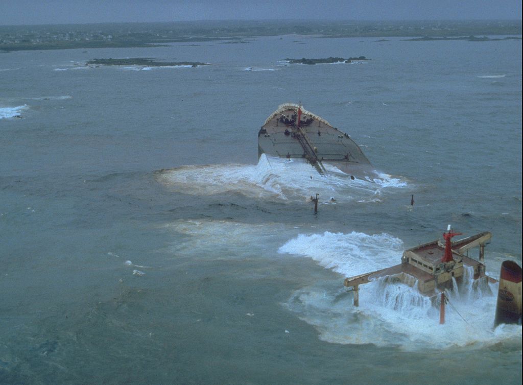
On the morning of March 16, 1978, Amoco Cadiz, an oil tanker was navigating through the rough sea of the English Channel. A big wave struck the rudder and the hydraulic system. The ship ran aground on the very sharp rocks on the island of Brittany in France at around 6:00 AM. Since the sea conditions were adverse, it was almost impossible for the rescue workers to do anything about the spill.  Even the rescue toe lines couldn’t last for a few hours. The shallow underwater rocks on the island finally damaged the hull and the leakage from the tanker began. 

From there onwards, over the next few days, more than 1.6 million barrels of oil spilled into the sea and spread over more than 200 miles along the French coast. The spillage killed millions of sea inhabitants and thousands of birds and contaminated the oyster bed in the region. The Amoco Corporation, the owners of Cadiz, agreed to pay $155 million as a claimant in the incident.

The Atlantic Empress – 1979

Amoco Cadiz Oil Spill

Atlantic Empress, which was in service for more than five years, collided with Aegean Captain on July 19th, 1979. The collision occurred on the coast of Trinidad and Tobago. During a tropical storm, both the ships couldn’t do much as the ships came on to a collision path and finally collided.

This became one of the worst disasters the oil shipping industry has ever faced at that time. Around 2.13 million barrels of oil spilled into the sea. Both the ships caught fire as a result of the collision but the response action was pretty quick. Rescue workers towed the burning Atlantic Empress to open waters where it burnt for several days and finally sank.

On the other hand, the Aegean Captain was towed towards the coast as the fire was controlled and the ship sustained minimum damages. Regardless of the fact that so much oil was spilled, there was minimal damages to the beaches and sea inhabitants as the wind directed most of the oil away from the shores and the oil very quickly dispersed. However, 27 sailors lost their lives. The estimated loss of oil from this accident was approximately 88.3 million gallons. 

Ixtoc 1 Oil Well – 1979

The Ixtox well is located around 50 miles NorthWest of Ciudad del Carmen Gulf of Mexico. The well at the time of the accident was operated by Pemex, a Mexican government owned oil drilling company. It is estimated the oil spill during the process was estimated to be 3.3 million barrels.

It all started in June 1979 when Ixtoc 1 oil well which was exploring oil at 50 meters in the water exploded. Subsequently, the platform collapsed and damaged the valves of the rig. This made it very difficult to close the rig and finally, the rig was sealed after nine months of rigorous hard work by the workers. 

The reason for the incident according to the experts was the drilling mud which failed to circulate, resulting in oil and gas pressure building up in the pipes. Operators tried to plug the hole but natural gas went up and by-passed the blowout preventer valve. As a result, it came in contact with motors up on the rig platform which eventually exploded leading to fire.

According to the experts, if the blow out protector valve had worked adequately and released the gas in the open air, the incident could have been avoided.

Over the course of the next nine months, the oil continued to pollute the beaches in the Western Yucatan Peninsula in southern Texas. This resulted in a loss of marine life. The tourism industry in the region also suffered. 

BP’s Deepwater Horizon Oil Spill – 2010

The most known oil spill of recent times is the BP Deepwater horizon. This accident also occurred in the Gulf of Mexico which is considered to be the hub of oil and natural gas. 

On April 20th, 2010 at around 3:00 PM, a pocket of natural gas blasted all the way up through the Cement well cap which was installed on April 8th of the same year. Subsequently the gas travelled up to the rigs and the platform was ignited as a result.

This immediately resulted in severe devastation on the site. The platform could not sustain the damages and two days later it sank in the water. This accident was a result of an error in BP’s engineering judgment. Due to this mishap, the company had to pay an amount of $65 billion in compensation.

To date, this remains the largest accidental oil spill.  The well was finally capped on September 17th the same year, almost five months from the day of the explosion. The amount of oil lost as a result of this accident is still not confirmed. According to the most accurate estimates, 4.9 million barrels of oil were lost. By the time, the well was capped, around 1,300 miles of the US Gulf Coast ranging from Texas to Florida was covered with oil.  

The accident resulted in the death of 11 individuals and left 17 injured. The loss was not restricted to human lives, but the marine species also suffered severely. Around 800,000 birds were killed as a result of this spill including a brown pelican which was recently delisted from the list of endangered species. Also, 6,500 turtles died.

There are many other oil spills, but these four mentioned ones remain the largest oil spills in the world. 

Salt Domes – An Economically Significant Geological Formation

Enlarged view of salt crystals

What is a Salt Dome?

A salt dome is a geological formation deep under the surface of the Earth. It is a vertical column of salt which protrudes upwards into the layer of sediments called the caprock. Salt formations are typically horizontal, but when in a sedimentary basin where a thick layer of salt is covered by a layer of sediments of heavy mineral, salt formations can rise vertically. 

How is Salt Domes Formed?

A phenomenon known as diapirism takes place beneath the surface of the Earth. It allows lighter material to force its way upwards through denser material. In the case of a salt dome, salt has a lower density compared to the rocks above it. When a gravitational force, tectonic force, and a combination of various other forces act upon salt, this results in the deformation of salt. As a result, the salt flows upwards like a viscous liquid. 

For the formation of a salt dome, the pressure on the salt must be high enough to allow the salt to penetrate through the layer of sediment above it. Once the salt begins to flow, the process will continue as long as the pressure on the salt is more than the forces acting against it, but once the forces are in equilibrium, the flow of salt will stop. 

When conditions are favorable, salt domes can grow thousands of feet above their core. They can also reach the surface of the Earth and result in the formation of salt glaciers. The formation of salt domes does not occur overnight. It is a long process which can take centuries. The process begins in an isolated marine inlet. When the water evaporates, it leaves concentrated salt. Geologists believe that the evaporation process should occur multiple times. This will help achieve the required concentration of salt essential for creating a salt dome

Once the large deposits of salt are created, wind and other external forces will come into play. Over time, sediments are deposited on the salt. Once the sediments have completely covered the salt formation, the forces acting on the salt will become stronger. Since salt is a mineral with lighter density, it will find its way upwards through the sediments. 

Size of the Salt Domes 

Salt domes are often very large structures. The diameter of the salt dome can range from ½ a mile to over five miles. The origin or the parent rock from which the salt dome rises is typically found thousands of feet below the surface. A typical salt dome rises at least a mile from its origin and some are known to be higher than six miles.

Economic Significance of Salt Domes 

Salt domes are important due to various reasons. They serve as a reservoir for oil and gas. They are also a critical source for sulfur and salt. Once the salt is extracted, the remaining salt dome holes can be used as an effective underground storage and waste disposal site for hazardous waste. 

Oil and Gas Reservoirs 

Salt domes have a unique significance in the oil and gas industry. As the salt is rising vertically, it exerts pressure on the rocks above it. The caprock, which is the layer of sediment above the salt, is arched upwards. This upward arch serves as a structural trap and can reserve oil and gas. As the caprock is arched upwards, oil and gas migrate towards the salt dome. Salt is an effective trap rock as oil can come to rest up along the salt. 

This upward arching of the rock and collection of oil and gas in the arch allows better flow rates of hydrocarbons. This helps in the extraction and recovery of fossil fuels trapped along the salt dunes. The extraction of hydrocarbons along the salt dunes is more cost-effective and environmentally friendly compared to conventional drilling. A single salt dome can have numerous reservoirs of oil and gas at various depths and locations around the salt dome. 

A Source of Salt and Sulfur 

Since salt domes are salt formations, they can be exploited through mining. Salt is used as an essential raw material in numerous industries. It is widely used in the chemical industry and for treating snow-covered highways. Apart from commercial use, salt also has domestic applications as well. 

Another important mineral that can be recovered from salt domes is sulfur. Sulfur is not a part of the salt dome but an important component of the caprock. It occurs as a crystalline material and is known to be formed as a result of bacterial activity. The caprock of certain salt domes contains enough sulfur that can be recovered economically. 

The process of recovering sulfur from salt dome involving drilling a well and treating the rock with superheated water and air. However, as of now, this method of recovering sulfur is not cost-effective. Therefore most of the sulfur which is produced today is a byproduct of refining hydrocarbons. 

Underground Storage and Waste Disposal 

When the salt, sulfur and hydrocarbons are extracted, this leaves large holes which can be used for underground storage. Some of the mines which are developed into salt domes are sealed and can be used for the storage of oil and gas. In the US and Russia, salt domes also serve as state reservoirs of helium gas. This is because salt is the only type of rock that has very low permeability. As a result, it can hold the tiny atoms of helium gas. 

Since salt has low levels of permeability, it also restricts the flow of any type of liquid into the soil. These properties make salt domes very effective for the disposal of hazardous radioactive waste.

Conclusion 

Salt domes are a distinct geological formation with great economic value. Though it takes centuries to form, once formed, humans can continue to benefit from them for years.  

Top Five Rice Producing Nations in the World

Rice crop in a field

Rice is one of the top three food crops grown in the world. Based on production and use of land, rice only follows maize and sugarcane. Around 78% of the total crop grown in the world is consumed by humans as food.

While it continues to be a dinner table essential, it has many other uses as well. It is used as a gluing agent in various industries and is primarily consumed in the Eastern part of the world, specifically Asia. Additionally, rice has some nutritional benefits, especially brown rice.

It is one of the very few crops which need a lot of water to grow. Hence, it is grown in areas where water is available abundantly. Rice, along with maize and wheat, is the main source of calories for almost 50% of the world’s population. It is cheap and easily accessible, and many different varieties of rice are available. Since it is a staple crop for more than half of the world’s population, rice cultivation is increasing every year.

However, with the ever-growing population, the consumption of rice is also on the rise. The rate is much higher than the cultivation rate. Another major issue with rice cultivation is the shortage of water. Thus more and more farmers are relying on genetically modified crops that can be grown in a shorter period with less need for water. 

Rice is mainly grown in the Asian belt with countries like China, India, Pakistan, and Bangladesh securing a place in the top ten list of the world’s largest rice producers. But the interesting fact is the same countries are also the world’s largest consumer of rice. 

It is estimated that the demand for rice will rise to 555 million tons in the current year as opposed to 490 million tons in 2019. It is also expected that Asians will be responsible for consuming 67 % of the total yield. An overview of top rice-producing countries is as follows. 

China

China tops the list of the world’s largest producers of rice. The largest producer of rice is also the biggest consumer, as it also tops the list of countries with the largest population. Rice, being a dietary staple in China is essentially part of every Chinese meal. The country alone produces 35% of the top world’s rice yield. China manages to produce around 197 million tons of rice every year.

The crop is grown on more than 30 million hectares of land. With technological advancements in genetic engineering and increased use of genetically modified foods, the yield of rice per hectare in China is much higher compared to other countries in the world. China consumes almost 148 million tons on its own. Whereas the rest is exported to other parts of the world. 

India

India secures second place on the list of top rice-producing nations in the world. The cultivation area of rice in India is more than in China. Rice is grown on 44.1 million hectares in India as opposed to 30.17 million hectares in China. However, due to the use of genetic engineering and hybrid seeds, the annual rice yield in China is more than that in India.

The annual yield in India is 148 million tons compared to 197 million tons in China. More than 50% of the Indian population feeds on rice as a primary food and consumes around 99 million tons of rice domestically. This also makes India the second-largest consumer of rice. 

Moreover, the government supports rice cultivation by providing subsidies on rice seeds, fertilizers, and machinery. Together India and China account for more than 55% of the total rice grown in the world. 

Indonesia

Third on the list is Indonesia. Compared to the two rice giants, rice cultivation in Indonesia is substantially less. The crop is grown on approximately 12.2 million hectares of land. 65 million tons of rice is produced annually in Indonesia, but the country only consumes 37.5 million tons. The rest of the rice crop is exported to other parts of the world. 

The global demand for rice is increasing very rapidly and Indonesia, which is the largest Muslim country, is playing an important role in meeting this demand. 

Bangladesh 

Bangladesh is the fourth-largest producer of rice and has the highest per capita rice consumption in the world. The crop is grown on 12 million hectares of land.  The annual rice production in Bangladesh is 47 million tons. Unlike the top three producers of rice where rice is grown on a large field, Bangladesh rice cultivation is usually owned and managed by families.

The annual consumption in Bangladesh is around 40 million tons. Thus, there is practically nothing left to export. Rice is considered as a food security in Bangladesh mainly because of the high consumption rate.

Thailand

The fifth-largest producer of rice is Thailand. With cultivation on an area of fewer than 10 million hectares, the country manages to produce more than 30 million tons of rice. However, the consumption of rice is around 10 million tons domestically. Hence, Thailand is one of the major exporters of rice around the world. Thailand is the largest exporter of rice with annual rice exports of around 18 million tons. The jasmine basmati rice grown in Thailand is one of the most famous varieties in the world.


Top Five Countries with Largest Reserves of Natural Gas

Stove with gas lights running
Source: https://pixabay.com/images/id-2257

Natural gas is considered to be one of the most essential fuels used in households. Natural gas, which primarily comprises methane is commonly used in oven and stoves in almost every country of the world. Chemically, natural gas is composed of one part of carbon and four parts of hydrogen. It is much lighter in weight compared to oxygen. This is the reason why it evaporates very rapidly. Natural gas has a pungent smell which can be noticed quite easily. 

This gas is an important fossil fuel and originally natural gas reserves were classified as associated and non-associated reserves. Associated gas reserves are found along with oil reserves. They can be extracted or transferred back to the reservoir. Non-associated gas reserves are gas reserves found independently. However, as of now, we categorize natural gas into two different types; conventional natural gas and unconventional natural gas, also known as shale gas. These two distinct types of natural gas are found in different types of rock formations. Regardless of the type, natural gas is primarily used as a domestic fuel. It also has wide industrial applications and is also used as an alternative fuel for vehicles. 

Today the global reserves of natural gas are estimated to be 7,121.4 trillion cubic feet. 80% of the total proven natural gas reserves are found in eight countries. It is expected that there are other reserves of natural gas, which are not proven so far. From the data of 2018, the top five countries with the largest reserves of natural gas are: 

Russia

Russia holds the largest reserves of natural gas in the world. As of 2018, the country’s reserves are estimated to be 1,688.23 trillion. This makes up for around 24% of the global reserves of natural gas. Hence, Russia has a big stake whenever the global gas prices fluctuate. More than 50% of the Russian gas reserves are located in the cold region of Siberia, specifically in the Nadym-Pur-Taz (NPT) region of the upper-western Siberia. The three largest gas fields in Siberia are Yamburg, Urengov, and Medvedev, which account for nearly 45% of the total country’s gas output.

Gazprom, a state-run company, is responsible for more than 80% of the gas production in the country. This is one of the biggest known stakes in a natural resource for a single entity as this accounts for 20% of the world’s gas production. 

Iran

Second on the list with the largest gas reserves is Iran. The country which has always been under political instability and sanctions has managed to capitalize on its natural resources. Iran is not only rich in natural gas but possesses many other natural resources. 

Iran holds almost 1,200 trillion tons of natural gas, which accounts for almost 18% of the total global gas reserves. The largest gas field in the world, the South Pars is located in Iran. More than 80% of the Iranian gas reserves are non-associated gas reserves. This means that they are not found along with reserves of crude oil. 60 % of the country’s total gas reserves are located in the ocean as South Pars extends to Qatar and a large part of it is in the ocean. This gas field is responsible for more than 25% of the country’s total gas output. Other major gas fields in Iran include the North Pars, Kish, and Kangan. 

Recently, Iran discovered a new natural gas reserve, which according to its oil ministry holds 19 trillion cubic feet (tcf) of the resource and could potentially produce 400 million barrels, worth about $40 billion. However, increased sanctions by the US may prove cumbersome and delay or even halt their natural gas exports from this area. We’ll have to wait and see how this plays out.

Qatar

Qatar, a Middle Eastern nation, which is the largest supplier of LNG liquid natural gas comes third on the list of largest gas reserves.. The country possesses around 175.5 billion cubic meters of proven natural gas reserves. The South Pars located in Iran extends to Qatar. This is the world’s largest offshore field holding the largest reserves of non-associated gas. Another major gas field located in Qatar is the North field. Also, the Barzan gas project played an important role in increasing the output of gas in Qatar since its completion in 2015.

Saudi Arabia

The global oil-producing giant and a leading member of OPEC comes fourth on the list. The country holds over 7.9 billion cubic meters of gas reserves which makes up almost 4% of the world’s total proven gas reserves. 

The Famous Ghawar onshore, Ghawar offshore, Safaniya, and Zuluf fields produce more than 50 % of the total gas output. These gas fields account for more than 55% of the total reserves in the country. There are many nonassociated gas fields in the country as well. They include the Karan field, Arabiyah field, and Hasbah gas fields. 

Turkmenistan

5th on the list is Turkmenistan. The country also holds proven gas reserves of 7.57 billion cubic meters which account for almost 4% of the world’s supply. The reserves are located mainly in the Amu Darya Basin in the South East and the Murgab South Caspian Basin which is located in Western Turkmenistan. The Dauletabad field is by far the oldest and the largest gas field in the whole country. 

The country lacks proper infrastructure and there have been very few developments when it comes to the oil and gas sector.  

There are some other major players when it comes to global reserves of natural gas. This includes countries such as Venezuela, Nigeria, Australia, Iraq, China, and Israel with exports planned to go to Egypt and Jordan shortly. Additionally, Israel recently signed a deal with Greece and Cyprus to export natural gas to these countries as well. 


An Overview of Shale Gas


What is Shale Gas?

Shale gas is natural gas that is trapped within the tiny spaces of shale formations. Shale is fine-grained rocks formed from mud, silt, clay and organic matter. It is a hard, low permeable mudrock and can be a rich source of petroleum and natural gas. However, the oil and gas trapped in shale are very difficult to extract because either it is trapped in small pores or is absorbed onto clay mineral particles that form the shale.  

With advancements in technology and the use of a combination of various extraction techniques, large volumes of shale gas have been extracted over the last decade. Extraction techniques such as horizontal drilling and hydraulic fracturing have allowed access to large amounts of shale which were previously uneconomical to produce. The extraction of this gas gives hope to the world where the energy demand is increasing exponentially. It is expected that the reserves of shale gas are enough to sustain the global economy for centuries. 

Shale Gas vs. Natural Gas  

Shale gas is a type of natural gas. It is a mixture of various hydrocarbon gases and consists mainly of methane. However, there is a difference in how the gas is distributed under the surface of the Earth. There is also a difference in how it is extracted from the Earth.

Natural gas reserves are formed when the gas travels towards the Earth’s surface. The gas originates from an organic-rich source into a permeable reservoir rock. This reserve of gas is trapped by another layer of rock which is impermeable. So essentially, natural gas is trapped between layers of two different types of rocks, but through vertical drilling, the natural gas is extracted. 

On the other hand, shale also forms from organic-rich sources. However, these sources are present within the shale rock. The rock is impermeable and this inhibits the gas to migrate towards the surface of the earth. As a result, the gas remains trapped within the rocks. To extract this type of gas, a combination of techniques called hydraulic fracturing and horizontal drilling is used. The wells are drilled horizontally. Later water, chemicals and sand are pumped into the wells to break the hydrocarbons. This process is known as hydraulic fracturing. Together, these processes allow for the extraction of the hidden resource. 

Global Reserves of Shale Gas 

There is a rising environmental concern on the extraction of shale gas. Insertion of water and chemicals into the wells can disturb the water table. It can also contaminate the potential sources of water for nearby habitats. However, considering the exponential increase in global energy demand, there is an increasing extraction of shale gas. 

It is interesting to note that many countries around the world hold large reserves of shale gas. Below is a description of the five countries which hold the largest reserves of shale gas in the world. 

China 

Shale gas exploration is a very recent practice however, it progressed very rapidly. China holds almost 770 trillion cubic feet of recoverable shale gas reserves with more than 26.98 trillion cubic feet of proven shale gas reserves. In 2016, the overall production of shale gas in China was around 280 billion cubic feet and it is expected to reach more than 1 trillion cubic feet by 2020.

Argentina 

Argentina is known to be the largest producer of dry gas. It also holds the second-largest reserves of shale gas. The country possesses 802 trillion cubic feet of shale gas. The extraction of shale gas from Argentina began after 2013 when Chevron and YPF, a vertically integrated energy company in Argentina, signed an agreement to develop the shale gas facility in the VacaMuerta field.  

Algeria 

Algeria, the largest country in Africa and the Arab world is also the third-largest country in the world when it comes to shale gas reserves. It possesses 70 trillion cubic feet of technically recoverable shale gas. Significant foreign investment from ENI, Royal Dutch Shell Plc and Talisman Energy Inc. will certainly play an important role in the development of shale gas facilities in Algeria. 

US

According to the estimates, the US holds the fourth-largest reserves of shale gas following China, Argentina and Algeria. It holds 665 trillion cubic feet of shale gas. As of now, the country is producing 87 billion cubic feet of shale gas per day. This product is expected to increase further. This increase in the extraction of shale gas has provided a boom to the US economy. It is estimated that the shale gas reserves are enough to sustain the energy needs of the US economy for the next 110 years.   

Canada 

Canada is one of the largest producers of natural gas in the world. It also holds the fifth-largest reserves of shale gas. It is estimated that the country holds 573 trillion cubic feet of shale gas reserves. There are significant explorations in Alberta, British Columbia and New Brunswick. However, due to inadequate local infrastructure and environmental protection laws, the country is unable to capitalize on this resource so far. Given the limited population and huge reserves of shale gas, the Canadian economy can continue to rely on this resource throughout the next century. 

Conclusion 

With the depleting natural resources and ever-increasing global energy demand, shale gas is the new ray of hope for the global economy. Apart from the list of countries, there are many other countries that hold large reserves of shale gas including Mexico, Australia and South Africa. Looking at the reserves, we can safely assume that this important resource can continue to meet the global energy needs for years to come. 

Tectonic Movements: How Earthquakes Happen

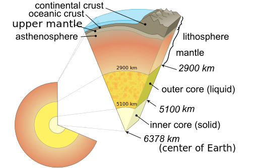
Earth cutaway schematic of the EarthFeeling the earth rumble under you has got to be one of the scariest moments you could experience. It may feel like the whole planet is moving and you are helpless to stop it or even run for safety. If you are one of those unlucky people who have experienced this, you are not alone, as thousands of others have also felt this unsettling thunder under their feet.

Fortunately, these movements, more commonly called – earthquakes, last less than a minute, but the damage they leave behind in both human lives and property is incomprehensible.

So you ask yourself – why did this happen? What can be done about it? Let’s delve into what causes earthquakes and see if we can remove the mystery of why the earth moves.

The Tectonic Plates

Map of earthquakes across the world
Fault lines across the world. Red indicates heavy plate movement and black depicts the most intensive earthquakes.
At a level that is just under the earth’s service, within an area called the lithosphere are platforms called tectonic plates. According to scientific studies, these plates move about 0.6 inches per year. The Rift Valley in Iceland is an example.

Slow-moving plates are of course nothing that we should really get excited about, but it is when there is a heavy movement of these plates that we should begin to worry.

The plates are broken up into 12 regions, like 12 pieces of a jigsaw puzzle that are connected to each other. When the plates move, they bump into each other at their connections, officially called boundaries, causing collisions, or conversely, breaking away from each other.

The image above is a historical account of previous earthquakes and depicts where these boundaries exist, which are called fault lines. The colors represent how intense the plate movements were; that is, how intense the earthquake was. It is also at these fault lines that when the plates move, volcanoes and tsunamis occur, and mountains can be created. As you can see, there is an abundance of fault lines across the entire west coast of the United States.

What lies directly under these plates is the source that causes the tectonic plates to move.

The Earth’s Mantle

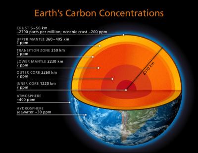
Under the Earth graphic cut away
Under the plates is the mantle, which consists of magnesium and iron-bearing silicates. You can think of the tectonic plates as the ‘skin’ of the earth, analogous to the skin of an apple. So when there is movement in the mantle, the plates above it feel this movement and they will move accordingly. How much movement is dependent upon the intensity of the changes within the mantle.

How are the Plate Movements Quantified?

Earthquakes are caused by these collisions, as one plate moves over the other the earth shakes. The measurement of intensity is rated using a Richter Scale, which records the magnitude of the collisions, with ‘1’ being unnoticeable, up to ’10’, which can cause massive death and destruction. Fortunately, an earthquake of ’10’ is very rare.

What is the Current Theory of Plate Movement?

The reason why the plates move is still under conjecture, but one theory is that heat from radioactive processes within the planet’s interior is what causes the plates to move.

The latest theory is called slab pull, where areas of the lithosphere become less dense than the asthenosphere. This causes these areas above to sink further down into the mantle, pulling slabs of the lithosphere apart, and causing the plates to move in different directions. As a result, these regions are spreading or rifting,

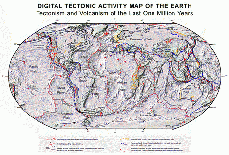
Tetonic activity map over the Earth's history
Tectonic Activity Map Over the last One Million Years

The Latest Findings

As it turns out, such interactions between continental plates is not the only reason for these various geological processes. Research led by a joint team of the University of Toronto and the University of Aberdeen has achieved an enormous breakthrough!

According to the study that uses supercomputers to run a model of the Earth’s upper mantle and crust, prehistoric geological events could have left deep ‘scars’ that may play a significant role in earthquakes, tsunamis, formation of mountains or ocean trenches, and many other ongoing geological processes.

The models created by the researchers indicate that the previous plate boundaries could stay buried deep below the surface of the Earth. These structures, which are no less than many millions of years old, are located far from the current plate boundaries and may cause drastic changes in the surface properties and structure of the interior of the continents.

The researchers went a step further to propose a new map highlighting the ancient geology of the Earth. The ‘perennial plate tectonic map’ explains through illustrations how these prehistoric geological events could affect today’s geological processes. The map is based on the common tectonic map, which is taught in elementary school, but it has been modified to include the concealed, ancient plate boundaries that may be involved in plate tectonic activity in the past as well as the present.

Owing to this breakthrough, some major revisions are required to the fundamental idea of plate tectonics. The research paper titled, ‘Lasting mantle scars lead to perennial plate tectonics’ appeared in the Nature Communications issue of June 10, 2016.

Conclusion

So we see that plate movements below the Earth’s surface can cause these disturbances to occur, but how they occur is still a forum for debate. At least we know where it happens most (fault lines) and as best we can, precautions have been and will be taken for earthquakes to minimize damage.

The Fundamental Forces of Nature

Everything which happens around us is a result of the interaction of forces and we mean everything, from a fruit falling from a tree (remember Isaac Newton?) to Earth orbiting around the Sun, aa matter around us interacts with other bodies around it, This phenomenon is based on four fundamental forces

Gravity, the weakest of the four natural forces is present in our everyday lives. It determines how and why things around us stay at a certain height and why some objects fall down, while others take longer. 

Electromagnetic forces run our electric and digital machines and allow us to access the universe from the comfort of our homes. 

The other two natural forces, namely the strong and the weak nuclear forces, operate at the atomic level. They influence the fundamental particles of an atom including the proton and electrons. 

Each of the four fundamental forces of nature has unique properties and characteristics. Every single interaction which takes place in the universe can be explained through these forces. However, there are certain interactions that appear to be bizarre and are not explained by these four forces. This raises the question of the existence of a fifth, unknown and unexplained force of nature. Physicists are still struggling to find the answer.  

Gravity 

Photo of Woman Falling Down
Woman in Free Fall. Photo: Unsplash_011722_Bruce-Christianson-XyZxxJI8g30-unsplash1

If a pen slips out of your hand, it will immediately fall down and touch the ground. For humans, gravity appears to be the strongest and most obvious force of nature. In reality, gravity is actually the weakest of the four elements, at least on this planet. It’s a whole different animal in outer space. 

Simply defined, gravity is the attraction between any two objects which have a mass. The force depends upon the mass of the objects. According to the law of gravitation, the magnitude or intensity of the gravitational force can be calculated by multiplying the masses with the universal gravitational constant ‘G’. The resultant is then divided by the square of the distance between the centers of the masses. There is a different force of gravity constant for each object in the solar system and for that matter, the universe. The formula is F = G*m1*m2/r2 . One example would be the force of gravity on Earth is 9.8 meters per second squared or 9.8 m/s2

Gravity is very weak on the atomic level, but since most objects around us have so much mass, the force of gravity becomes stronger and more apparent. The force becomes stronger and more evident for universal objects with larger masses including the planets and stars. In this case, gravity is strong enough to keep them in an orbit. When it comes to galaxies, the mass further increases and gravity plays a crucial role in attracting galaxies even when they are far apart.  

The Weak Nuclear Force 

The weak nuclear force is much stronger than the gravitational force (1010 times). However, the force is only stronger within a certain range. It acts at a distance within the size of the proton. The particles which carry the weak nuclear force are called the weak vector bosons and have symbols w+, w-, and z0. The interaction between these particles causes one type of charged particle to turn into another type of charged particle. This interaction is responsible for phenomena such as beta and other radioactive decay

Electromagnetic Force 

Animated illustration of the electronmatic force's polority
Representation of the electric field vector of a wave of circularly polarized electromagnetic radiation. Photo: Wikimedia

The electromagnetic force, also known as magnetism is far stronger than the gravitational pull and has a much wider range than the weak nuclear force. It easily overrides gravity and it the third strongest force of nature is 1040 times stronger than the gravitational force.

An easy way to assess the strength of the electromagnetic force is to hold a magnet against a few paper clips. Gravity will attract the paper clips downwards but the electromagnetic force, which is stronger than gravity, will end up attracting the paper clips upwards. 

The electromagnetic force allows the interaction of particles with an electric charge. When the charged particles are at rest, they interact through electrostatic forces. When in motion, they mingle together through both electrical and magnetic forces. 

Though less powerful than the strong nuclear force, the electromagnetic force is by far the most prevalent force in the world. It can affect objects with a fair amount of power when they are at a reasonable distance. 

A military compass that was used during World War I

The Strong Nuclear Force

The strong nuclear force is the strongest fundamental force of nature. It is the biggest influence on the fundamental particles of the universe. It is this force that binds together the nuclei of the atom. However, the range of the strong nuclear force is only limited to subatomic particles. 

The nuclei of an atom are made up of a positively charged proton and a neutral charged neutron. Since like charges repel, each proton in the nuclei is working hard to get away from the other proton. This is where the strong nuclear force comes in. The strong force allows particles called gluons to stick together and create nucleons. These gluons can interact with other gluons and further strengthen the bond within the nuclei. The presence of a strong nuclear force is the reason why so much energy is released when the nuclei of an atom break down. 

The Fifth Force – Fact or Fiction 

Physicists around the world have unanimously agreed that the four fundamental forces explain every phenomenon (that we know of) in the universe. However, there are various mysteries of physics that cannot be explained by these four fundamental forces of nature.

One such mystery is the existence of dark matter. After immense research, physicists have agreed that dark matter is a form of a stable and huge particle that experiences gravity but no other known forces. Researchers have failed to identify the reason why dark matter does not experience any force other than gravity. 

There are many ideas about why other forces do not act on dark matter. One famous hypothesis is the presence of an unidentified fifth force. Physicists around the world are studying the possibilities of the existence of a fifth fundamental force of nature. But it is too early to claim its presence.