Category Archives: Weather

The Goldilocks Zone – Just Right!

International Space Station looking over the Earth and its atmosphere
International Space Station Looking Over the Earth and its Atmosphere

Solar System Planets

Remember learning about our solar system in elementary school? Our teacher gave us this verse: “Mary’s Violet Eyes Makes John Stay Up Nights. Period”. Well, as we all know now, the “Period” which represents Pluto is no longer a planet. It was reduced to a dwarf planet and not considered to be large enough to be part of our planetary solar system anymore. So we are left with Mercury, Venus, Earth, Mars, Jupiter, Saturn, Uranus, and Neptune.

Which Planets in Our Solar System Have an Atmosphere?

All of them except Mercury. It is just too close to the sun to sustain one. But if Mercury is the only planet not to have an atmosphere and thus, not allow life as we know it to thrive, why is there no life on the other planets aside from Earth? 

The Goldilocks Phenomenon 

Scientists call it the Goldilocks Theory. We like to call it something a bit more sophisticated – The Goldilocks Phenomenon, but any way you look at it, we are alive today because the atmosphere above us is the partridge that is just right! 

The Five Atmospheric Layers

If you draw a line from the first layer (the troposphere) to the last layer (the exosphere), it would be approximately 62 miles in length. As we work our way up through the layers, they each get thinner until they (the atmospheric gasses) dissipate). 

The line is called the Kármán line and is the accepted standard where scientists say the atmosphere meets space, but it is not a strict designation, as it is hard to say exactly where the gasses dissipate completely into outer space. There are so many factors to consider, the temperature being one of the main disparities since this component may differ within different parts of the earth.

With this in mind, let us define the five layers: troposphere, stratosphere, mesosphere, thermosphere, and exosphere.

Graphic of the 5 atmospheric layersThe Troposphere

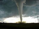
Ever realize that when you go into an airplane, it gets colder as you go higher? Air is warmer near the ground and gets colder higher up. Nearly all of the water vapor and dust in the atmosphere are in this layer and that is where clouds are found here. It contains about 99% of the water vapor, called condensation within the earth’s entire atmosphere and consequently, this is where all of the weather conditions materialize. So it might not be much of a surprise that the troposphere contains about 80% of the total mass of the entire atmosphere.

The Stratosphere

This is probably the best known layer as we frequently hear about NASA’s spacecrafts  “reaching the Stratosphere”. It is also where most of our jet aircraft fly. This layer extends about 31 miles above the ground, so if the troposphere runs approximately six miles high, the stratosphere picks up at the six/seven-mile marker.  

Another common term we hear a lot is the ozone layer. Well, it’s the stratosphere that contains this sub-layer which acts as a natural atmospheric shield by absorbing harmful radiation from the sun. 

Due to man-made pollution, a gap in the ozone layer developed. It extended 6.3 million square miles at one point, but there are positive signs that this hole is naturally healing itself and is the smallest it has ever been at this time.

The Mesosphere

In one of our recent articles on deep mining, we spoke about temperatures reaching as high as 145° degrees. Now we go to an area you wouldn’t want to venture to either, but this time the temperatures go in the opposite direction; that is, way low to about −225°.  Now that’s cold and is the average temperature in this layer. Ironically though, it is also the layer where meteors burn up when entering the earth’s atmosphere.

Any water in this layer here freezes into ice clouds. They make for some beautiful colored skies. The scientific name for them is noctilucent clouds, also called polar mesospheric clouds (not to be confused with the northern lights, which are different). These mostly blue-like clouds are visible at sunset from each of the earth’s poles.
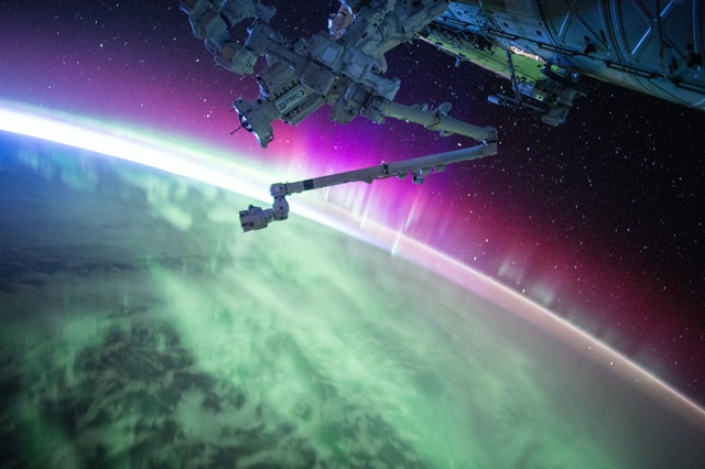
The Thermosphere 

This layer extends between 310 and 620 miles and temperatures can get up to 2,700 degrees. The International Space Station orbits here and this is the layer where we do see the northern lights, also called the Aurora Borealis and Aurora Australis.

The Exosphere

We have reached the final destination. The air is extremely thin here, but unless you are excited with an abundance of hydrogen and helium, just be content to know that the end of the exosphere is where outer space begins.

Conclusion 

What’s your favorite layer? Before you answer, the best bet is to take a ride up there. The next flight to the International Space Station is set for October 22, 2020. Register early. We hear that the bookings are filling up fast! 


Mighty Tornadoes and What Makes Them So Twisted?

2007 Elie Manitoba tornado

Natural disasters are a grave reminder of how helpless man is against the forces of nature. Tornadoes are just one of the many destructive forces of nature that can uproot you within seconds and throw you around like cardboard chips. Hence, it is important to know and learn about them as much as we can to make sure we are at least better equipped mentally to face the deadly aftermath of this catastrophe.

So what exactly is a tornado?

According to the National Weather Service, a tornado is

“A violently rotating column of air pendant from a thunderstorm cloud and touching the ground”

It is basically a moving column of violent air that is connected with the ground and a cumulonimbus cloud (in most cases) as the same time. In the United States, there are around a 100,000 thunderstorms that form within a year’s’ time; and there are 600 to 1,000 thunderstorms each year that bring tornadoes with them.

Tornadoes can form in almost any state; but the states that are most affected include Texas, South Dakota, Oklahoma, Nebraska, Missouri, Mississippi, Louisiana, Kansas, Iowa, Indiana, Illinois, Georgia, Florida, Arkansas, and Alabama.

So how much do you know about tornadoes? Let’s find out!

These destructive machines of nature are a weather-related event. Normally, a tornado’s path of expected to be around four hundred yards wide and four miles long. But don’t be fooled! Some tornadoes may surprise you with a hundred-mile long path and about a mile wide! They can reach a height of about 60,000 feet – you think the Giant in “Jack and the Beanstalk” would have been that tall or is it just us?

A tornado can move at an average speed of between twenty five and forty miles per hour, but there are some that can chase you at an astounding seventy mile per hour speed. And that’s just the tornado; the winds inside it have a speed of their own – let’s say they can swirl around at almost three hundred miles per hour. There is no way you can beat that!

If we observe the average stay of a tornado on the ground, it is hardly ever more than an interval of about five minutes, but the tornado keeps returning to the ground, and the touchdown could be several times in a row!   

So which direction do these tornadoes move in? Allow us to enlighten you.

Tornado in the Midwest

These tornadoes really have a strong sense of direction – we mean, how else would the tornadoes rotate clockwise in the southern hemisphere and counterclockwise in the northern hemisphere? Also most tornadoes are founding moving to the northeast from the southwest.

Another interesting fact about tornadoes is that a majority of them occur in the time span between 3PM and 7PM. Although these tornadoes occur across the globe in many different countries, United States gets the largest share of them, and they’re also the most destructive ones to occur. On an average, the United States faces almost eight hundred tornadoes each year.

Do you know how many people are killed by tornadoes each year? The figure comes around ONE HUNDRED!

Ten Interesting Facts about Floods in the US

A bench partially submerged in flood water
Photo by gufoto – yayimages.com

To experience the devastations of floods, you don’t necessarily need to live in a high-risk flood zone. Regardless of where you live, floods can severely affect you. As the global climate is changing, there is a tremendous increase in the frequency of floods. Every year, floods are becoming more intense and causing more damage to life and property. 

The United States experiences floods very often. This is because the country is prone to many other natural disasters. Some interesting facts in the United States are highlighted below. 

Floods Can Occur Anywhere 

Where there is water, there can be floods. This natural disaster can occur anywhere, anytime. In the United States, flash floods can occur in all 50 states. They are triggered by a preceding event like a hurricane or a storm. 

The eastern part of the US often experiences hurricanes and severe thunderstorms. Both of these conditions can trigger flooding. On the other hand, the western part of the US is more prone to snow melts and heavy rainfall. 

Flash Floods May Develop Quickly 

Flash floods may develop is as little as six hours following the triggered event. In case of a dike or levee breakdown or the collapse of a dam, flash floods can occur within minutes. They may take slightly longer in case of excessive flow of river water through ice melts.

While heavy rainfall is one of the potential causes of floods, other natural disasters including hurricanes, storms, and snow melts can also lead to flooding. 

Floods Follow Tornadoes

In terms of loss of property and lives, floods are the second most destructive natural disasters in the United States. Tornadoes are the only natural disaster that has caused more damage in terms of life and property compared to floods.  

In the year 2011, the total damages from floods were $8.41 billion. As the intensity and frequency of floods has increased over the last few years, the damages also hiked.

Flooding is a “Top 5 Causes” of Weather-Related Deaths in the US

In the year 2014, flooding was the 4th leading cause of weather-related deaths in the US. The National Oceanic and Atmospheric Administration collected the data regarding fatalities due to natural disasters for the years 1984-2013. The data revealed that the average deaths related to flooding was 85 per annum. This was highest amongst other natural disasters including tornadoes, lightning strikes, and hurricanes.  

Floodplains Are Just 2% of the Earth’s Surface 

Floodplains are areas that have a higher risk of floods. They are low lying areas near the rivers and other water bodies. Naturally, only 2% of the Earth’s surface can be categorized as floodplains. The rest of the surface of land also gets affected by floods, but not as much as floodplains. 

Though floodplains experience extensive damage due to frequent floods, they play an important role in maintaining the ecosystem. Floodplains maintain the level of groundwater by absorbing flood water and releasing it gradually. They also provide clean water, wildlife habitat, and crops.  

Wetlands Save Costs

Flooding incurs a major repair cost as it extensively damages property and infrastructure. In the US, wetlands save more than $30 billion in damage repair. Since wetlands act as sponges, they absorb and store excess water. As a result, flood water does not remain standing. A single acre of wetland can absorb up to 330,000 gallons of water. This volume of water is enough to submerge thirteen homes. 

Apart from saving costs, wetlands play a crucial role in maintaining groundwater levels.  

Floods are Becoming More Frequent and More Intense 

Over the last few decades, the US has experienced major shifts in the weather. There has been a 20% increase in heavy rainfalls. Heavy rainfall has increased the frequency of floods. This, combined with the increased use of land, has intensified damages from the floods. The average annual loss from floods has increased from $6 billion in 2013 to $10 billion in 2017. 

Considering the global climate change, scientists have predicted that the weather will further worsen in the United States. The size of the floodplains in the US will increase by 40% in the next 50 years. This can have devastating consequences on future generations. 

Dikes or Levees Can Collapse 

Civilizations have been residing around rivers for centuries. When the technology was limited, people living near rivers built levees or dikes. This was their only defense against overflowing floodwater. As technology improved and dams were constructed, people continued to rely on levees. 

In the US, 100,000 miles of levees run across the nation. However, there is no record of the condition of these levees. An estimate of 40% of the population in the US lives in counties that still rely on levees. People now do not rely on levees for agricultural purposes alone; instead, homes and businesses are now constructed behind them. However, with the growing intensity of floods, levees are no longer a reliable option. 

Heavy rainfall induced by climate change, along with the deteriorating condition of the levees, can pose a threat to the population residing near rivers and streams.